Our Earth in more than just colour
Germany is making a major contribution to climate protection with the environmental mission EnMAP (Environmental Mapping and Analysis Program). The satellite was launched from Cape Canaveral (Florida) on 1 April 2022 and has already delivered its first high-resolution images. EnMAP is the first hyperspectral satellite developed and built in Germany. The mission’s motto is ‘Our Earth in more than just colour’ because each EnMAP image is divided into a great many small wavelength ranges – many more than the human eye can perceive. Its innovative hyperspectral sensor technology lets us see our planet in a different light. This will reveal subtleties that have remained hidden until now. Due to this level of detail, it will be possible to quickly detect changes in our environment and thus contribute to the protection of our climate and our planet. In this way, EnMAP will help us make global land use sustainable, highlight the consequences of climate change and counteract ongoing environmental degradation – an important contribution to the health of our planet. With its two spectrometers, it analyses the solar radiation reflected from Earth’s surface at wavelengths ranging from visible light to short-wave infrared – at a hitherto unparalleled spectral resolution. This information can be used to make precise statements about conditions on Earth’s surface and how they are changing.
The EnMAP environmental mission is managed by the German Space Agency at DLR in Bonn on behalf of the Federal Ministry for Economic Affairs and Climate Action (BMWK). OHB System AG was commissioned to develop and build the satellite and its hyperspectral instrument. The German Research Centre for Geosciences (Deutsche GeoForschungsZentrum; GFZ) in Potsdam is the scientific lead for the study.
Three DLR institutes and facilities have been commissioned to set up and operate the ground segment. The German Space Operations Center in Oberpfaffenhofen will conduct and monitor satellite operations, while the German Remote Sensing Data Center and the DLR Remote Sensing Technology Institute will archive, process and validate the received satellite data and make them accessible to users in the scientific community. Companies and public authorities will also be able to view the data and use them to prepare future services. The use of EnMAP hyperspectral data by universities and scientific institutions and the development of special applications will be supported by BMWK funding programmes.
Links:
Deutsches Zentrum für Luft- und Raumfahrt (DLR)
Dr. Sebastian Fischer · E-Mail Sebastian.Fischer@dlr.de
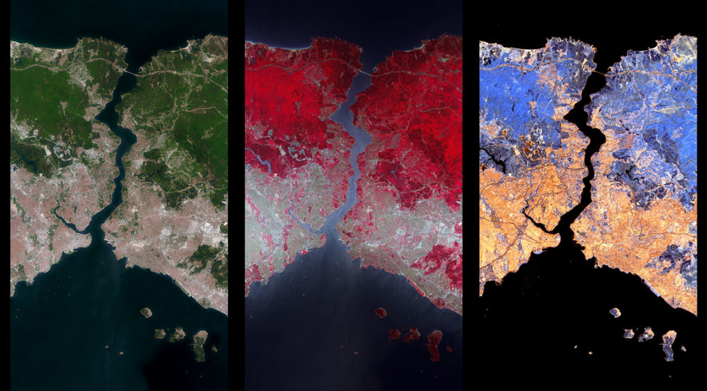
EnMAP – one image, a wealth of information. The German EnMAP environmental satellite has imaged a strip approximately 30 kilometres wide and 180 kilometres long over Istanbul in Turkey with its hyperspectral instrument. These three sections are each approximately 30 kilometres by 54 kilometres and show the Bosporus, where the European continent meets the Asian continent. The left image shows a true-colour representation, which roughly corresponds to human colour perception, with this area being scanned by the VNIR camera with almost 50 individual narrow channels. The centre image is a false colour image from the VNIR camera. In the near infrared, differences in vegetation become visible, which are related to the plant species and their condition, such as their biomass and chlorophyll content. The image on the right was taken with the SWIR camera in the short-wave infrared. Here, special features in the soil such as clays and in the rock, such as lime, can be identified and conclusions drawn about soil fertility.
The hyperspectral satellite EnMAP has delivered its first images of Earth. Project manager Sebastian Fischer describes the images and explains what conclusions can already be drawn from them.
